


[Part 1]: Site Analysis Diagrams

A slope and tidal study of the existing Bold Point Park site located in Providence, RI.
[Medium: Ink pen & Prismacolor Marker on Vellum.]

A water flow study looking at the tides of the Providence Bay and the countering flow of the Seekonk River in relation to the Bold Point Park site.
[Medium: Ink pen & Prismacolor marker on Vellum]

Diagram looking at existing parks, roads, and neighborhood adjacencies to Bold Point Park.
[Medium: Ink pen & Prismacolor marker on Vellum]
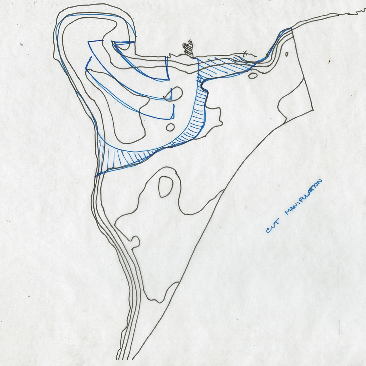
Looking at the operation of cut on the landscape I began to think about how I could manipulate the existing topography in order to interact with the tidal fluctuations on site and how I could enhance the small marsh condition that was thriving on the site. I proposed a series of cuts at varying depths to allow water to come further into the landscape and allow further take over of the marsh conditions.
[Medium: Ink pen & Prismacolor marker on trace paper]

Looking at the operation of fill on the landscape I began to think about how I could manipulate the existing topography in order to interact with the tidal fluctuations on site and how I could enhance the subtle topographic changes already present on the site as well as create a new flow on the site for water and people.
[Medium: Ink pen & Prismacolor marker on trace paper]
[Medium: Ink pen & Prismacolor marker on trace paper]
[Part 2]: Landform Study Models

Landform "scrape" intervention study.
Scrape - The action of pulling/pushing the surface back and gathering material, such as earth, while doing so.
[Medium: clay]

First study looking at slope and shaping a potential landformation for the site. This landform was thought of as a way to conceal or protect a space for gathering on the site that could then allow access to people on it's slope to a high point on the site for viewing of the Providence Bay area.
[Medium: clay]

Second study was a landform that would allow tides to flow in and out of it at given times of the day in order to reveal and conceal the landscape and provide opportunity for the marsh condition existing on site to grow in a protected area.
[Medium: clay]
[Medium: clay]

Using the clay studies of proposed landform for the site, I did a test using water and gradually raising the water level in order to trace the contours that would make up this intervention. This was to help me better understand how steep my design would be and how it would be constructed in contours.
[Medium: clay]

Contour plans of two detail models looking at potential scale and shape of proposed landforms for the site from testing in water and forming in clay forms.
[Medium: Ink pen on Vellum]

Contour model of landform designed for gathering space on site using the contours revealed by the water test on clay study model. Proposed viewing platform added to intervention that can be accessed from sheltered area by a gradual slope.
[Medium: 1/16" chipboard cut with laser cutter from file generated in Rhino.]

Contour detail model of landform designed for collecting water on site from rising and falling tides.
[Medium: 1/16" chipboard cut with laser cutter from file generated in Rhino.]
[Medium: 1/16" chipboard cut with laser cutter from file generated in Rhino.]

Construction model of first landform detail to better understand how the shape and slope of the landform would be constructed and maintained using a concrete retaining wall on the sheer side and embedded geo-textile system to control erosion on the sloped side.
[Medium: corragated cardboard, chipboard, foam, mesh, and paper.]
[Part 3]: Final "Scrape" Intervention

Parti of project showing how landforms begin to inform circulation and movement on site in their edge condition (example - the red being the sharp retaining walls constructing a sharp slope) and orientation.
[Medium: Ink pen & Prismacolor marker on Vellum]

Circulation diagram of final design on site showing how movement and rest of people is dictated by landform and edge condition.
[Medium: Ink pen & Prismacolor Marker on Vellum]

Hydrology diagram of final design showing how landform is covered or exposed by tidal conditions related to the site at high and low tide.
[Medium: Ink pen and Prismacolor marker on Vellum]

Vegetation and materials diagram of final design.
[Medium: Ink pen, Prismacolor marker, & colored pencil on Vellum]

Final grading plan (1:30 scale) of final design for Bold Point Park. Drawing includes proposed contours, platforms, graded paths, and bridges needed for circulation along the site that can be revealed or concealed depending upon the tides.
[Medium: Plan generated in Rhino and details hand drawn with ink pen.]

Final contour model (1:30 scale) for design of Bold Point Park showing details such as platform locations, bridges, and tide fluctuations that may occur on site and how these conditions can be revealed or disappear depending upon the time of day. (Dark blue is water level at low tide.)
[Medium: 1/32" chipboard, balsawood, & Prismacolor marker. Contours generated in Rhino and laser cut.)


